Use Case · Agriculture & Primary Sector
Agricultural & Fishing
Crop analysis with multispectral sensors, plot mapping with LiDAR and fishing zone surveillance for efficient and sustainable management of the primary sector
Crop analysis with multispectral sensors, plot mapping with LiDAR and fishing zone surveillance for efficient and sustainable management of the primary sector
Agriculture and fishing face growing pressures: drought, pests, yield losses and fishing resources under strain. Decision-making based on accurate, up-to-date field data is the key to maintaining competitiveness and sustainability.
IMS VTOL drones equipped with multispectral, thermography and LiDAR sensors can generate NDVI index maps, detect water stress or pest hotspots, map plots with centimetric precision and monitor fishing resources — all in a single autonomously programmable, recurring mission.
The same VTOL platform covers everything from crop analysis on large farms to surveillance of fishing grounds and aquaculture zones, adapting sensors to the environment.
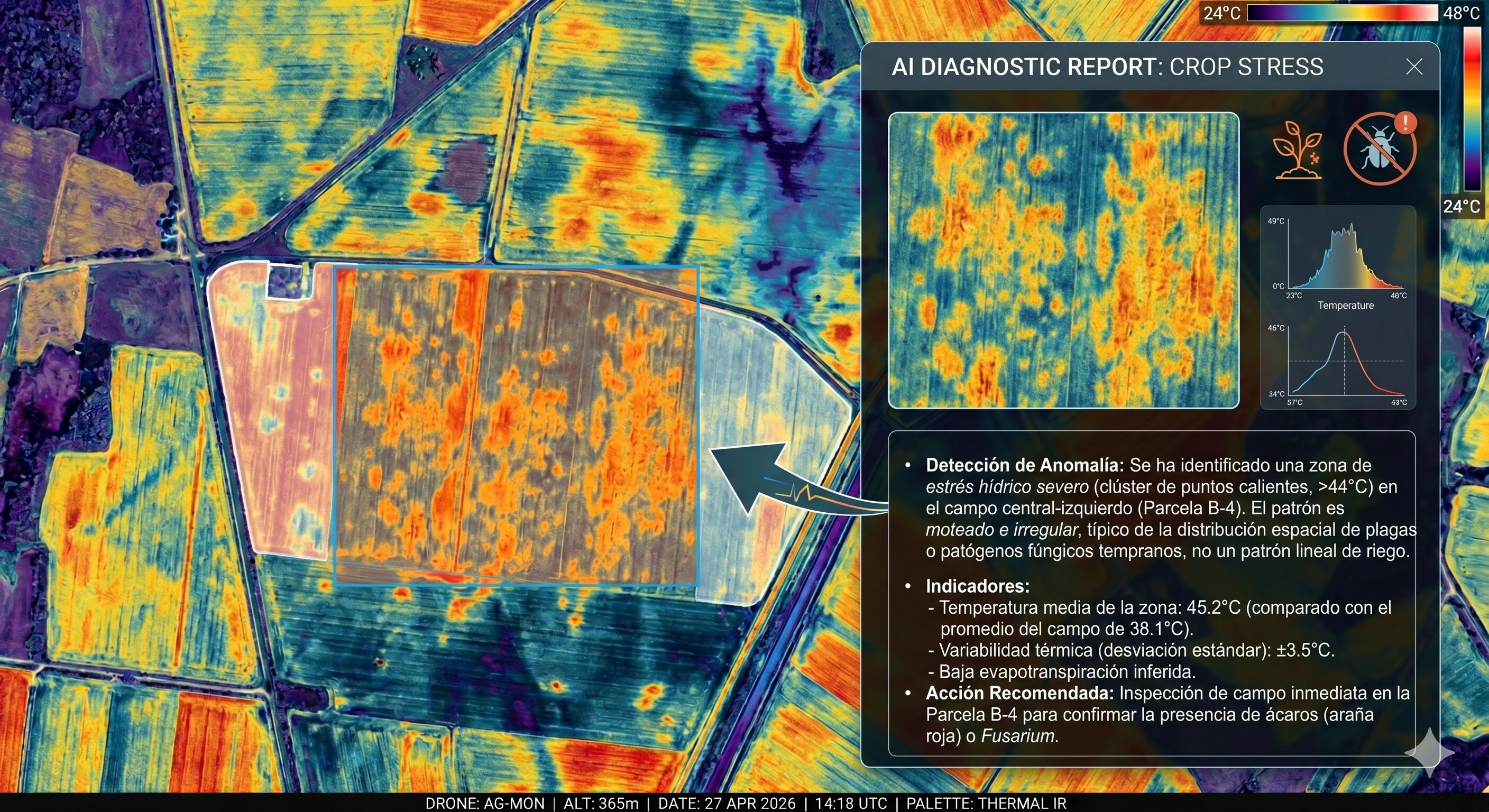
Crop analysis with multispectral camera (NDVI/NDRE), early detection of pests and water stress, soil moisture maps, plot mapping with LiDAR and terrain modelling to optimise irrigation and phytosanitary treatments.
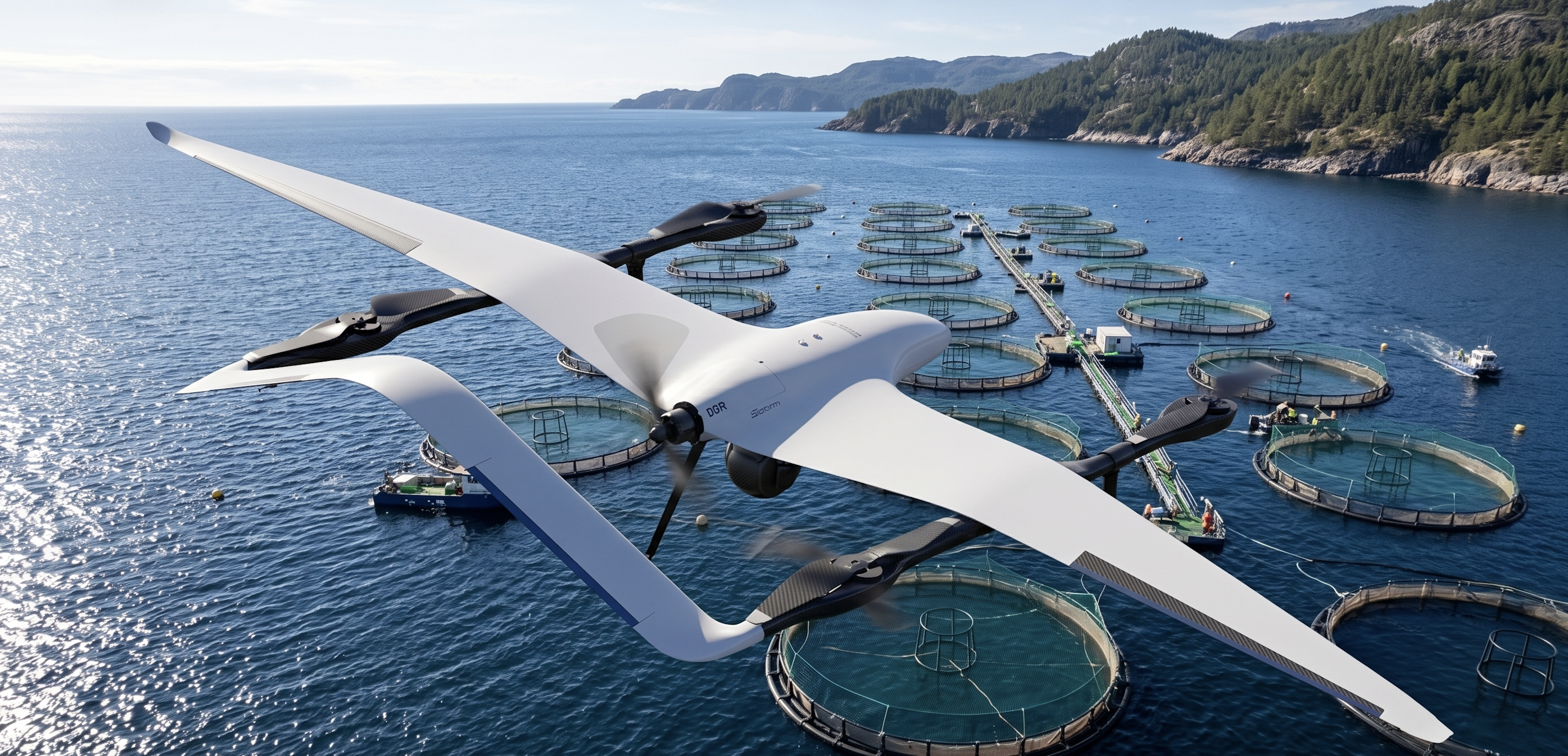
Monitoring of fishing grounds, aquaculture zones and fishing coasts. Detection of illegal vessels, water quality analysis by thermography and support for sustainable marine resource management via georeferenced data.
Each flight generates an actionable information layer on the real condition of the crop: zones with water deficit, disease hotspots, terrain variability or changes in biomass. Reports are delivered in GIS formats compatible with the leading agricultural management systems.
Generation of multispectral maps to assess crop vigour, health and stress with centimetric resolution, enabling plot-by-plot precision treatments
Identification of infection hotspots before they are visible to the naked eye, reducing crop losses and phytosanitary use by up to 40%
High-resolution thermography to detect zones with water deficit and generate irrigation prescription maps, reducing water consumption without affecting yield
Centimetric plot surveys for area measurement, slope analysis, drainage planning and cadastral management with ±3 cm RTK accuracy
Overfishing, illegal fishing and coastal ecosystem degradation are real threats to the sector. IMS VTOL drones provide continuous coverage of large stretches of coast and open sea, generating valuable information for fishing authorities, fishermen's guilds and aquaculture companies.
Long-range autonomous maritime patrols to supervise fishing zones, detect unauthorised activity and support real-time catch traceability
Periodic inspection of cages, mussel lines and rafts. Detection of structural damage, contamination or irregular activity with 4K optical camera and thermography
Thermal mapping of sea surface temperature to identify upwellings, currents and zones with potential for harmful algal blooms affecting the sector
Georeferenced recurring data for authorities and fishing guilds: zone inventory, ban period monitoring and marine environment evolution analysis throughout the campaign
Contact our technical team to design a sensing solution tailored to your crop or fishing zone